
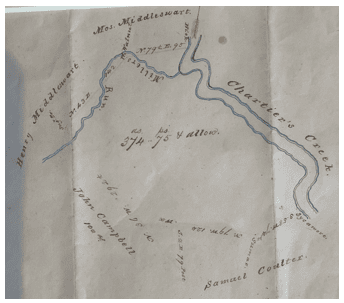
On one of my recent visits to the Woodville Experience I came across the original survey for “The Mouth of Miller’s Run”, the property warranted to John Campbell in 1790, three hundred and seventy-four acres on the southwest shore of Chartiers Creek that includes, today, the I-79 Interchange.
It is not surprising that such a document should appear at Woodville – Presley Neville sold that specific block of land to Robert Johnson in 1807. We know that John Campbell still possessed the property in the 1790s and was advertising a “caveat” against Christian and Frederick Lesnett regarding ownership of a block of land adjacent to it. By 1809 John Campbell was a Justice of the Peace in Peters Township in 1809; we assume he sold the property to Presley Neville at least a few years prior to that time.
The deed for the property describes it as beginning at “a sycamore on the Bank of the creek” and then proceeding through eight legs each bounded by a pair of trees – “shumac”, white oak, hickory, etc. – to a hickory on the bank of the creek, and “thence up the creek by the several courses 410 P. to the place of beginning”.
An example of the description of a typical leg is “Thence by land of Henry Middleswarth N 43o E 142 P. to a white walnut”. This particular leg began at a “sugar tree” and proceeded on a bearing of North 43 degrees East for 142 perches terminating at the white walnut tree. Such a description is an excellent example of the precision of surveys in the eighteenth century.
The term “perch” (or pole or rod) is a unit of measurement equal to sixteen and a half feet. It is derived from the use of a long pole for measuring distances. It was standardized at one-fortieth of a furlong. An intermediate unit is the “chain”, sixty-six feet (one tenth of a furlong), so named because a chain of that length with one hundred links was developed for use in surveying.
In Medieval times in England all the land was owned by the King, and assigned to Lords, who then rented it to tenants. The “open fields” were subdivided into acres, with an acre being the amount of land a tenant with a team of oxen could plough in one day. Because of the difficulty of turning a team of oxen, furrows were extremely long; this led to the term “furlong” for a distance of 660 feet. An acre came to be defined as a rectangular area one furlong long by one-tenth of a furlong wide (66 feet).
Let’s imagine the eighteenth century surveyor setting out to record the location of the corners of this particular warrant on March 17, 1790. His tools are a compass with a sighting bar and a sixteen-and-a-half-feet long pole. He begins at a sycamore tree close to the mouth of Coal Pit Run and sights a “shumac tree” about a quarter of a mile in the distance, which has been identified as a corner of the property. He measures the angle as being fifty-eight degrees west of due south. His crew proceeds along that line, measuring it at seventy-four perches. For reference, twenty-one years earlier a different surveyor had measured the angle at sixty degrees and the distance at seventy-three perches.
My interest, of course, is in attempting to superpose this survey onto a present-day map and to locate precisely the area it encompasses. This turned out to be more difficult than I suspected. The first problem is the fact that all the corner markers were trees and it is impossible to locate them today. Fortunately one of them appears to be close to the point where Coal Pit Run enters Chartiers Creek.
A tour of the boundary of this warrant today would begin at the mouth of Coal Pit Run and proceed about a quarter of a mile to the southwest paralleling the stream, crossing the Washington Pike north of at the Scheetz complex and terminating at a point just south of Melrose Cemetery. From there the next leg is south about two thousand feet, crossing the Pike and ending up near Bursca Street.
Leg four is nearly a mile long proceeding to the northwest along the hillside, then down the hill crossing Route 50, and Miller’s Run, terminating near the stream in the vicinity of the intersection of the Presto-Sygan and Miller’s Run Roads. The next leg is to the northeast about half a mile to a point in the midst of the Newbury development, about halfway between Route 50 and the Bethany Cemetery.
From there the boundary runs about a quarter of a mile to the northeast, hitting Chartiers Creek about two thousand feet south of the present location of Miller’s Run entering the Creek. From there the boundary is the southwest bank of Chartiers Creek going upstream to our starting point.
In 1810 Robert Johnson purchased this property from Presley Neville for about ten dollars an acre. An unskilled laborer earned one dollar a day in 1810; if we assume he would earn twenty dollars an hour ($160 a day) today, Johnson paid the equivalent of $1600 an acre. I suspect the assessed value of that land is close to $100,000 an acre today.
The original Campbell block has seen a lot of history in the intervening twenty-three decades. In addition to the massive I-79 interchange it has witnessed the evolution of the Catfish Path to the Washington Pike. It has housed Melrose Cemetery, part of the Selden chemical plant, three railroads, Scotts Ponds, the Pittsburgh Board Speedway, the El Rancho Drive-in movie theater, and an athletic field that was home to Bridgeville and South Fayette High School sports teams as well as the Morgan Strasser soccer teams. If any of the “witness” trees that served as survey corners have survived, they could tell an interesting story.

- Fourth Annual Sculpture Exhibition Kicks Off At Bridgeville Library - April 13, 2025
- Oyler: The Twenties Did Indeed Roar in Bridgeville - January 13, 2023
- Oyler: Operation Pastorius - February 3, 2022